Wednesday, 4 April 2018

What Exactly Is The La Niña Phenomenon?

La Niña is a climate pattern phenomenon that pertains to the cooling of surface ocean waters along the tropical west coast of South America. La Niña is the counterpart to El Niño wherein the equatorial region of the Pacific Ocean are marked by unusually warm ocean temperatures.

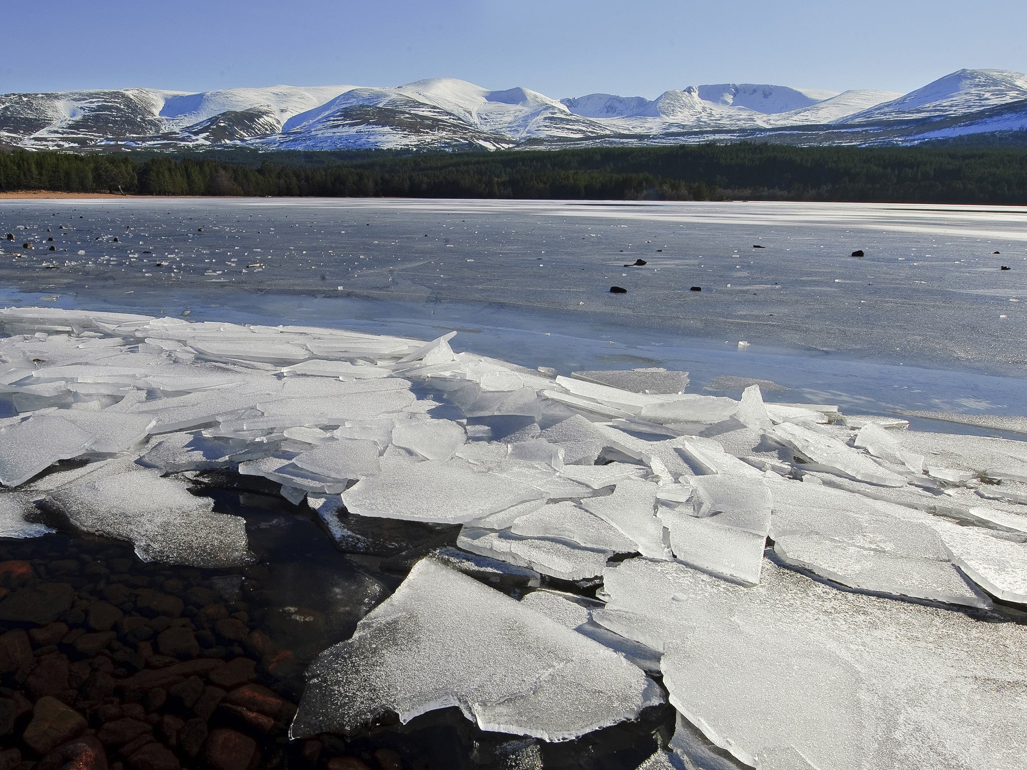
Image source: independent.co.uk


In some areas of the world, La Niña causes increased rainfall. Conversely, it generates extremely dry conditions in other regions. The conditions that cause La Niña recur every few years and can last for as long as two years. El Niño occurs every two to seven years, and La Niña sometimes follows El Niño. In the past, La Niña has been called the anti-El Niño and El Viejo, which means “old man” in Spanish.

The phenomenon happens when the easterly trade winds get stronger and blow more warm water west allowing cold water below the sea’s surface. It thus pushes toward the top near the South American coast, replacing the warm water. This means that the easterly trade winds are to be blamed for partly causing La Niña.

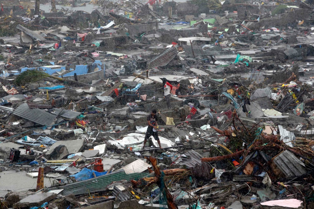
Image source: nydailynews.com


When La Niña occurs, the sea surface temperatures across the eastern and central Pacific Ocean tend to be lower than the typical 3 to 5 degrees Celsius. The main effects of La Niña include increased rainfall, catastrophic flooding, and drier than normal conditions.

Jim Byrne is a weatherman and former chief meteorologist for KCOY CBS-12. For more on his work and interests, visit this blog.

Monday, 12 March 2018

NASA’s Role In Weather Forecasting

Image source: NASA.gov
Earth science is one area of focus of the National Aeronautics and Space Administration (NASA), which includes studying Earth’s weather system such as the dynamics of the atmosphere and its interaction with the land and oceans. Through its expertise and technology, weather, ranging from local to microphysical processes, can be predicted with a fair degree of success at about a maximum of two weeks prior.

NASA deems improved knowledge of weather processes and phenomena a crucial ingredient of understanding Earth further. In addition, there is an infrastructure in the United States for operational meteorology at NOAA, the FAA, the DoD, and other agencies requiring the introduction of new technologies and knowledge that only NASA can develop.

NASA contributes to national weather forecasting goals primarily through developing and using data from space-based sensors. For over two decades, satellite-based profiles of temperature and moisture have been regularly used in forecasting, while new NASA sensors promise to upgrade accuracy and spatial resolution.

Image source: ClimateCentral.org
Other technologies supporting weather, as developed by NASA’s earth science division, include the In-Space Validation of Earth Science Technologies (InVEST) program (RainCube and CIRis) and the EV class missions such as CYGNSS and TROPICS.

As a recent development, NASA’s Joint Polar Satellite System (JPSS) comprises four weather satellites that will provide advanced forecasting on not only hurricanes but also dangerous weather events that threaten communities across the country.

Weatherman Jim Byrne is a consulting meteorologist at the Weather Channel program “So you think you’d survive.” An alumnus of San Jose State University, he had also been the chief meteorologist for KCOY CBS-12 and a freelance weekend meteorologist at NBC Bay Area. Read more on this page.


Saturday, 10 February 2018

Can You Predict The Weather By Yourself?

Image source: tematicaresearch.com
Some people might wonder if they can predict the weather without having to rely on forecasts. If you are one of those who do, the simple answer is yes. Here are some ways to do it:

Observe the direction of the wind: How the wind blows can be indicative of approaching weather. If the wind moves in from the west to the east, that could be an indicator that the weather would be good, while wind going in the opposite direction suggests that bad weather is coming. Another thing to watch out for is the behavior of smoke from a fire. If it does not rise steadily and spirals back down, it means that there is low pressure and that it will rain soon.

Watch out for the “calm before the storm”: There is a reason that expression came to be. Looming bad weather means there is low pressure, and this pushes out normal wind patterns, leading to lack of wind on the ground and calm or still water. The brightness of the moon may also be an indicator, as low pressure clears out dust that would have covered the moon a little bit.

Image source: almanac.com
Check out animal behaviors: Animals are capable of determining if bad weather is on the horizon. For example, ants build up their hills so that the sides would be steep to divert rainwater. Birds fly lower than usual or perch at branches nearer the ground because low-pressure air irritates them. Insects, particularly bees and butterflies, become less visible as they have already returned to their home for safety.

Jim Byrne is a weatherman who currently serves as a consulting meteorologist for the Weather Channel program and is the former chief meteorologist at KCOY CBS-12. To see more discussions about the weather, check out this Facebook page.


Friday, 15 December 2017

The Lighter Side: Amusing Conspiracy Theories About The Weather

While the weather as a whole is a serious matter, it helps that once in a while people take a break and find some humor and entertainment in it. There are countless pop culture references pertaining to the weather. Entire disaster movies have been built around its theories and concepts. Let’s take a look at one of the more amusing aspects of weather – the conspiracy theories.

Image Source: guardian.ng

The European Rain Thieves

Mahmoud Ahmadinejad was known to be a conspiracy freak. Many have also considered him to be deranged. But that didn’t stop Iran from making him president. One of the most famous conspiracy theories Ahmadinejad came out with during his regime was that of European nations actually stealing rain.

Ahmadinejad theorized that the countries of Europe had come up with a device that drained rain clouds over Iran and took them westward to Europe.

Fair Radiation Servings

Solar radiation management, otherwise known as SRM, refers to a set of methods and techniques that help lower radiation from the sun. The primary means of SRM is to spray chemicals that reflect radiation back into space. While governments all around the world have applauded this effort to reduce radiation, global warming, and climate change in general, conspiracy theorists are quick to suspect that there are sinister intentions behind this, and that countries are using SRM to control weather and use it as a weapon.

Image Source: watchers.news

Jim Byrne is a consulting meteorologist for the Weather Channel show “So You Think You’d Survive” and an active member and past president of the Rancho Maria Men’s Golf Club. He is the former chief meteorologist for KCOY CBS-12 and freelance weekend meteorologist at NBC Bay Area. For more updates from Jim Byrne, click here.

Wednesday, 15 November 2017

Kicking In The Rain: Tips For Playing Soccer In Bad Weather

For dedicated athletes, playing in the rain brings excitement and a whole other level of performance. Yet, doing so might result in accidents that could hinder them from playing for a long time. Slips and other risks should be avoided if one decides to play in bad weather.


Image source: unsplash.com

While there are many indoor courts soccer players can play in, the quality of turf isn’t the same as the one outdoors. The pleasant experience of playing in real grass while the sun is out is what soccer players are after. Rains may strike in the middle of the game, and if there are no lightning strikes and heavy winds, a game may continue. The following tips may guide players how to their game safe even in bad weather:

  • Put more pace on the ball - During heavy rains, the grass becomes sloppy, and a ball might get stuck during a pass. Pass harder to get the ball to target player.
  • Play the ball in the air - The ball moves slower on the ground and playing more direct can give a team fewer chances of being intercepted by the opposing team.
  • Slide tackle - When the grass is wet, a player’s risk of being scraped by the surface is lessened. During the rain, it’s much easier to do this defensive skill.
  • Be mindful of the skip - A ball may skip because of the layer of water in the grass. Know where to place the ball and how to run with it.


Weatherman Jim Byrne is a consultant for the Weather Channel program “So you think you’d survive” and a former chief meteorologist at KCOY CBS-12. For more weather discussions, visit this blog.


Monday, 30 October 2017

Preparing the home for a blizzard

Blizzards are nasty events that nature designed to wreak havoc on entire cities during the winter time. As such, a lot of preparation is needed to help people get through these snow storms. If a home is not ready to cope with the weather, the results are oftentimes disastrous. Here are a few pointers in preparing for a blizzard. 


Image source: mashable.com

  • As soon as people receive reports of an incoming blizzard, they should prepare all their lanterns and rechargeable lamps. It’s highly recommended that every household have a wind-up lamp. 


  • People should also have transistor radios ready so even with the electricity cut off, they can still gather the latest developments from the storm. 


  •  Communication devices such as phones and walk-talkies should be charged so people can talk to their loved ones and see how they’re doing. It’ll also come in very handy when people experience an emergency and need help themselves. 


  • Having the home equipped with a freeze alarm can be useful during the winter months. If a person is on their way home and they get notified through the app that their house has lost power and there’s a sudden drop in temperature, they may look for other options to kill time. 

Image source: wordpress.com

Jim Byrne is a weatherman and former chief meteorologist for KCOY CBS-12. Learn more about him and his work by checking out this blog.

Wednesday, 30 August 2017

The strongest storms in recorded history

Forces of nature are fascinating and terrifying at the same time. Perhaps no other calamity is as far reaching and affects as much of the world as oceanic storms. Throughout history, storms have come out from the oceans to batter those living on land. Early civilizations would even come up with legends of how gods and monsters would conjure these destructive winds and rains. More modern societies have studied these patterns and have devised countless safety measures to minimize destruction of property and loss of life. 

Image source: livescience.com

Let’s take a short look at two of the strongest storms in recorded history. 

Typhoon Nancy 

The undisputed strongest typhoon in history, based on the strength of her winds, Typhoon Nancy brought a path of destruction that many governments and research centers still study up to this day. The debate though is whether the info on her is reliable. What was more devastating was that it sustained her strength for over five whole days, which is a record. 

Typhoon Violet 

Typhoon Violet at its strongest was one of the most intense storms ever recorded. Only Nancy was stronger. One fortunate fact about Violet was that it didn’t last long. Whereas Nancy held the record for lasting the longest as a category 5 typhoon, Violet died down after only a few days.

Image source: nbcnews.com

Jim Byrne is a seasoned weatherman and the former chief meteorologist for KCOY CBS-12. For more fascinating discussion on the weather, check out this blog.